Suomi satellite reveals Earth’s dark side

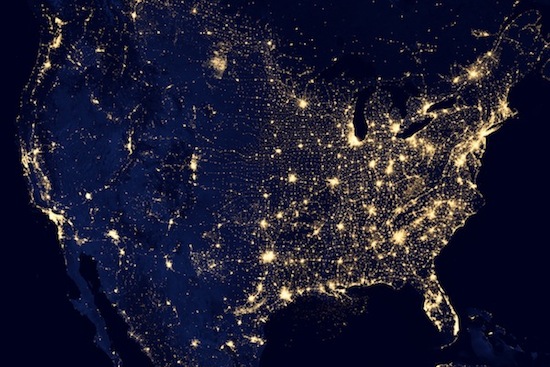
The Suomi National Polar-orbiting Partnership satellite captured this nighttime image of the United States.
Photo: NASA
A remarkable new view of the dark side of our planet from space released today by NASA and the National Oceanic and Atmospheric Administration is just a peek at the nighttime capabilities of the agencies’ newest weather satellite, the Suomi National Polar-orbiting Partnership.
Named for the father of satellite meteorology, University of Wisconsin–Madison professor Verner Suomi, the Suomi NPP satellite is taking images of unprecedented quality from orbit 500 miles above Earth — especially at night.

Suomi
The Day Night Band, which is the instrument responsible for the “black marble” picture — released today (Dec. 5, 2012) at a meeting of the American Geophysical Union — is part of the Visible Infrared Imaging Radiometer Suite (or VIIRS) onboard Suomi NPP.
“It can observe dim light down to the scale of a single ship on the ocean at night,” says William Straka, a researcher at Madison’s Cooperative Institute for Meteorological Satellite Studies, “or the dull glow of the aurora lighting up the night sky.”
The predecessor to VIIRS was an Air Force defense satellite. Suomi NPP makes high-resolution nighttime images using the visible spectrum of light accessible to the civilian science community at large, which means they can be used in a variety of applications.
Instead of snapping one exposure to produce a photo, VIIRS scans sections of the Earth several times. Millions of pixels in each scan are analyzed individually and balanced so that dark spots are amplified and bright spots don’t obscure their neighbors.
“It’s like having three simultaneous low-light cameras operating at once and we pick the best of various cameras, depending on where we’re looking in the scene,” says Steve Miller, a researcher at NOAA’s Colorado State University Cooperative Institute for Research in the Atmosphere.
The VIIRS Day Night Band is sensitive enough to be able to capture visible images of the Earth’s atmosphere — even on moonless nights — by making use of very faint, nocturnal atmospheric light called airglow. The results include awe-inducing pictures of bright cities scattered across the globe, but also the best tool meteorologists have to monitor visible weather conditions at night.
Phenomena like the often-dense marine fog which forms at night along the coast near San Francisco, are clearly visible at night in the Day Night Band, adding detail and confidence to weather advisories issued by the National Weather Service.
“But there are other things than the clouds in the atmosphere that are constantly happening at night that would interest people,” Straka says.
Suomi NPP is sensitive enough to see the burning volcanic caldera of Kilauea in Hawaii, fires burning in remote forests of the United States and Australia, and the undulations of auroras at both ends of the Earth.
It can see the lights of fishing boats — which can reveal the patterns of commercial fishing traffic along boundaries laid out in international fishing treaties — or serve up the presence or absence of light across the continents as a proxy for tracking human activity and growth.
In addition, the Day Night Band can show the absence of light due to a natural disaster, such as the aftermath of Hurricane Sandy. Nighttime imagery from before and after Hurricane Sandy made landfall in October showed the size and scope of blackouts and damage in in New York and New Jersey. And then how quickly (or slowly) power was being restored to swamped cities along the East Coast.
“There is a lot more detail than we expected, and we seem to find new and interesting things constantly,” Straka says. “Having the ability to see what is going on at night has so many uses for various government agencies and social and environmental scientists, as well as groups that we haven’t imagined yet.”


