Capturing tomorrow’s satellite data with today’s instruments
A satellite that won’t be launched into orbit until 2015 is already paying dividends for an advanced weather research project.

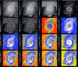
In a project called the GOES-R Proving Ground, scientists from the UW–Madison Cooperative Institute for Meteorological Satellite Studies (CIMSS) are taking advantage of future weather satellite capabilities to improve today’s forecasting and atmospheric research. Here, hurricane Katrina is viewed via several simulated data streams for the GOES-R satellite revealing different component parts of the storm. Only five of these data streams are available on the current GOES-12 satellite.
Scientists from UW–Madison’s Cooperative Institute for Meteorological Satellite Studies (CIMSS) are participating in a project designed to bridge the gap between current satellite capabilities and the advanced technology that will be part of the next generation of geostationary satellites.
Previously, satellite data could not be utilized until the spacecraft was actually in orbit. Once the craft was in place, scientists had to play “catch-up,” hurrying to learn what they could do with the new technology and how best to do it. This delay wasted valuable satellite “life-time” and resulted in a lag in delivering useful products to weather forecasters and other users.
With the upcoming Geostationary Operational Environmental Satellite, the GOES-R, things will be different.
In a project known as the “GOES-R Proving Ground,” scientists are taking advantage of currently available weather studies capabilities (via satellite, terrestrial, and computer models) to accurately preview various aspects of future GOES-R capabilities. Their goal is for both developers and users of GOES-R observing systems to have a firm grasp of the satellite’s capabilities even before it is launched. In addition, they seek to introduce upcoming GOES-R research products to weather forecasters and the environmental community.
Tim Schmit, a National Oceanic and Atmospheric Administration (NOAA) scientist located at CIMSS, says, “You can create proxy data using actual data from existing polar satellites. Or you can use a series of high-resolution numerical models, using current data to emulate what the future satellite will see. We can use a situation from the past, collate the data collected back then, and show how it will look with the expanded measurement capabilities that will be available on GOES-R.”
Once it is fully operational the GOES-R satellite will provide 68 separate data streams, providing vital weather and climate information, including cloud formation, volcanic ash distribution, turbulence, and sulfur dioxide concentrations.
Using knowledge and techniques perfected in the GOES-R Proving Ground, sophisticated simulations of most of these data streams will have been created by the time the satellite is actually in orbit. Researchers and forecasters can become accustomed to using data from a satellite that has not yet been launched.
Thirty-five of these simulations are being developed at the UW–Madison by CIMSS and NOAA scientists.
Some groups are already benefiting from the GOES-R’s capabilities. NOAA’s Storm Prediction Center saw a need for quicker identification of Convective Initiation, the rapid upward growth of cumulus clouds that can signify a coming severe weather event.
CIMSS scientist Wayne Feltz says, “Using currently available data, we re-quantified the Convective Initiation process so we could signal that initiation was occurring. The Proving Ground gave us the opportunity not just to develop the algorithms, not just to do basic research into the algorithms, but to improve the product by working with the end users. We’ve actually designed new applications, like Convective Initiation — products that have never really existed before — in anticipation of the instruments that will be on GOES-R. We’ve found that we can use the data right now.”
Using the new system, the Convective Initiation product indicates some severe weather can be reliably detected up to 45 minutes before significant radar echoes of the storm.

