Geography students put local foods on the map
As temperatures warm, farm fields begin to green and outdoor farmers’ markets get under way, the time is ripe for thinking about local foods. For Madison residents, finding locally produced foods is now just a mouse click away.

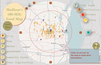
The 100-Mile Diet Map, created by geography students, is an interactive, online map of food sources within 100 miles of Madison.
Four UW–Madison geography students have created an interactive, online map of food sources within 100 miles of Madison. Their 100-Mile Diet Map aims to educate consumers and provide a central resource for those interested in eating close to home.
Touted as a way to access fresher food from known sources, reduce transportation costs and invest in the local economy, the 100-mile diet refers to eating only foods that were grown or produced within a 100-mile radius of your home. First described by a Canadian couple in 2005, the 100-mile diet concept has grown in popularity recently as people become more concerned about the environmental and social consequences of their food choices.
The idea resonated strongly with a group of geographic information systems (GIS) certificate program students enrolled this spring in geography professor Mark Harrower‘s Animated and Web-Based Mapping class. For Althea Archer, of Bemidji, Minn.; Heidi Banfi, of Deerfield, Wis.; Fran Ellsworth, of Madison; and Megan Turner, of Madison, a 100-Mile Diet Map sounded like the perfect end-of-semester project.
Mark Harrower, a geography professor and cartographer, challenges his students to design Web-based maps that address real-world problems. "Who needs this map, and who’s going to use it? What community would benefit?" he asks.
Harrower, a cartographer, challenges his students to design Web-based maps that address real-world problems. "Who needs this map, and who’s going to use it? What community would benefit?" he asks. "We don’t just make stuff for the heck of it; we make it because there’s an obvious need."
Madison is lucky to have a variety of local eating resources, says Turner, but information is often scattered and not always user-friendly. "Maps are a powerful tool to clarify concepts and to organize data," she says. "We wanted to make it visually appealing with simple directions while also functional."
In addition, the reality of eating locally can seem daunting even for people interested in trying it. "I think people view it as a challenge," says Banfi. "One of the goals of our map is to show that it’s easy."
"The food map is a great example of taking on … a really current topic," Harrower says. "It’s such a geographic and spatial problem, and yet I’ve not seen any maps that help you figure this one out."
One of his requirements is that students work with real data. The food map group members gathered much of their information from local organizations, including the Madison-based nonprofit Research, Education, Action and Policy on Food Group (REAP) and the Madison Area Community Supported Agriculture Coalition (MACSAC).
An initial public version of their map shows the locations of a variety of local-food sources, including farms, farmers’ markets, food cooperatives and restaurants that serve locally produced items. For each, an icon links to contact information and what products are available, from fresh fruits and vegetables to meats, cheeses and eggs. Other links direct users to general information about the 100-mile diet, the benefits of local eating and ways to plan a diet based on seasonal local foods.
Map users can tailor the food map to their own needs by selecting a subset of information — for example, viewing sources of a specific type of product or finding nearby farms involved in community-supported agriculture, a system where people can buy farm shares at the beginning of the growing season in return for a share of the harvest throughout the year.
"The benefit of having this be an interactive Web map is that there are lots of different layers," says Archer. "The average user who just wants to know what the 100-mile diet is can go to the Web site and read and learn more. But if you’re already doing it and you’re in the middle of winter, and you realize, ‘Oh no, I’m running out of vegetables — where can I get some?’ you can use it too."
Of course, some foods cannot be produced locally in Wisconsin — coffee, chocolate and olive oil are three big ones — but the students point out that consumers still have choices about where to buy such products. For example, they’ve chosen to include local coffee roasters and chocolatiers on their map.
"Even if the source for the coffee isn’t local, at least the processing is done locally," Archer says.
Ellsworth adds, "I think there will always be food products that people aren’t willing or able to give up that aren’t locally sourced. But I think minimizing them is the goal. I’m not giving up my bananas. But there’s no reason we should get spinach from California."
She and the other students hope to dispel the idea that eating locally requires radical changes and to show how small steps can fit into many everyday lifestyles.
"The goal of this isn’t to be hard and fast and not eat anything from outside of 100 miles, it’s trying to get people’s attention shifted more toward that idea," says Ellsworth. "If everyone tried to incorporate as many food items from within 100 miles as possible, that’s a lot more powerful than five people being so strict that they won’t even cook their food in olive oil."
They also challenge the notion that local products are more expensive than conventionally sourced counterparts.
"Especially with food costs skyrocketing and gasoline prices going up, it may be cheaper to buy a quarter of a cow — or whatever — from a local farmer and put it in the freezer," Banfi explains. "Educating people about their other options is important."
Though the food map started as a class project, the women will continue to maintain and expand it, possibly adding interactive resources such as recipes, blogs and even food preservation tutorials. They also intend to make the map seasonal so users can see what products are available even in the dead of winter. Ultimately, they hope to see this type of map expand beyond Madison and even beyond the state.
"It’s a lot of work … But I really want to see it nationwide, so that you can put in your address and find out what sources are available within 100 miles," Archer says. "That’s the big-picture dream."
All four women will receive their professional GIS certificates this month.


